Formation of Barbados | Lesser Antilles Volcanic Arc
Hey there 🌞
Welcome back to the Science of Travel Blog! And if you’re new , welcome! I’m so happy you found your way here! On this blog we talk about Earth and the geology of landscapes and travel destinations.
Today, you’re going to find out why Barbados exists. You excited? I am because this article has been a long time coming!
Barbados is a dream destination for many. But few know why this tiny island in the Atlantic exists at all and I think only few ever wonder why it exists at all. Let me tell you the story of the formation of Barbados. And if you ever travel there, remember this magnificent story.
Barbados is a tiny island in the Atlantic ocean, about 13 °N (of the equator). It's considered to be part of the Caribbean and is a dream destination for many, with turquoise waters, white beaches and, thanks to its location within the tropics, a very pleasant climate.
Just about 100 miles (160 km) to the west are the volcanic islands of the Lesser Antilles, such as Montserrat, St. Lucia, St. Vincent and the Grenadines and Martinique (just to name a few). In this article I write about how an island completely made of sedimentary rocks (Barbados) can exist so close to volcanic islands with active volcanoes.
If you look at a map you can see that the Lesser Antilles are located between the Caribbean Sea (west) and the Atlantic (east). They're clearly arranged in a curve, an arc!
Like what you're reading? Sign up for the STORIES OF EARTH NEWSLETTER for more sophisticated content:
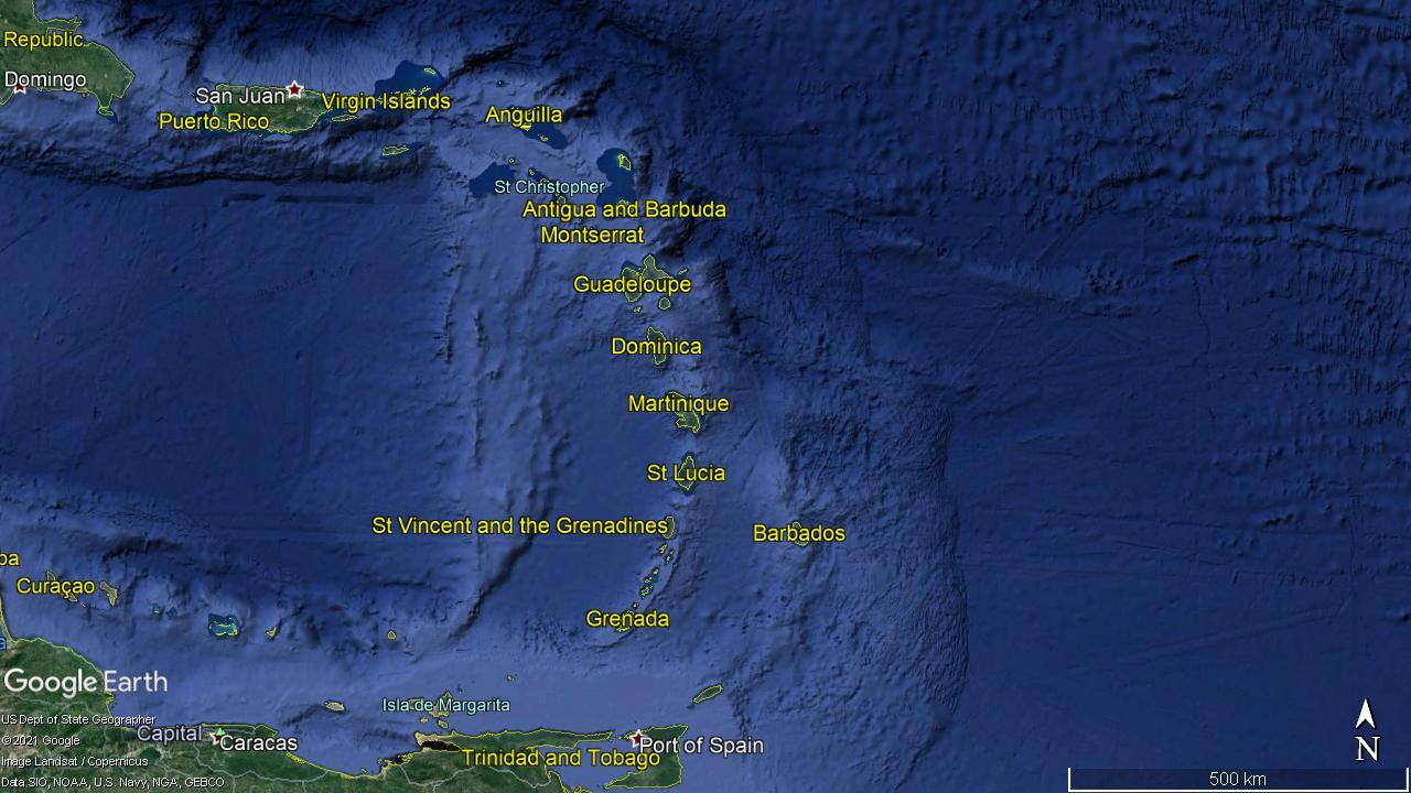
Now you could wonder: why isn't Barbados part of this island arc? Why is it located so much further east? Why is it isolated?
There are major differences between these islands: morphologically, that means in their shape and form, as well as geologically. The islands of the Lesser Antilles are all born from volcanoes and have volcanoes, active volcanoes, and are mountainous whereas Barbados is rather hilly, with Mount Hillaby as the highest peak with about 400 m or 1300 ft.
Barbados doesn’t have a volcano. The rocks of the Lesser Antilles are volcanic rocks, the rocks in Barbados are mostly limestones.
So how is it possible that a small, flat island that merely consists of coralsand and mud exists so close to volcanic islands made out of volcanic, crystalline rocks?
It's easy to ignore this and to simply think: Well, it's just there. Does there HAVE to be a reason for this?
I want to challenge this notion and claim that the position of these islands is no coincidence.
You might have heard that the La Soufrière Volcano on St. Vincent and the Grenadines has been erupting earlier this year.
I wanted to know why there is volcanism at all in this part of the world. I hadn't learned a lot about the tectonic situation in the Caribbean, so I did a little research.
I quickly found out that my initial assumption was correct and that indeed this volcanism is subduction volcanism. So what does that mean?
The island of St. Vincent and the Grenadines, where the volcano La Soufrière is located, is part of the Lesser Antilles Volcanic Arc which I've already introduced. This volcanic arc lies directly above the subduction zone.
The Earth’s crust is separated into tectonic plates. There are oceanic and continental plates. But these plates aren’t fixed on our planet, but they move around due to density differences. That's why our continents take on different forms over eons and eras.
What is a subduction zone?
A subduction zone is a region on Earth where two tectonic plates collide.
The one plate with the greater density, usually the oceanic plate, will be subducted. This simply means that it dives down below the other plate which is less dense. Colloquially you could say the subducted plate is "heavier", but that isn't entirely correct. It's better to say it's denser. If a continental crust and an oceanic crust collide, they create volcanic arcs on continents.
In our case, in the Lesser Antilles Islands region, there are two oceanic plates colliding. This kind of tectonic setting is resulting in a different kind of morphology: the volcanic island arc.
Here's a schematic cross-section of a subduction zone. You can see the one plate (here called lithosphere) that is being subducted.

While the plate is being dragged down into the Earth's mantle, the crust (the ocean floor which is being subducted) is being dehydrated, it looses its water because of the increasing heat and pressure. The water rises into the overlying mantle and causes the mantle rock to partially melt. This creates magma! The magma rises because it is less dense than the mantle rock, makes its way to the Earth's surface, creates volcanoes and the magmatic arc which we know as the Lesser Antilles Island Arc.
And now Barbados is joining the stage. In the image, you can see a yellow triangle called accretionary prism. Remember this for later.
At the Lesser Antilles, the Atlantic plate is being subducted below the Caribbean plate (there are discussions about which plate, the Atlantic or American or both, is being subducted, as the boundaries are not super clear, but that's not important for now).
The now molten rock (magma) rises, penetrates the crust and forms volcanoes on the surface, such as the currently, violently, erupting La Soufrière Volcano.
Side note: This is a different kind of volcanism than in Iceland. In Iceland, two things happen:
- The North American and Eurasian Plate don't collide, but are moving away from each other. This is called a divergent plate boundary. In the Lesser Antilles area, there is a convergent plate boundary.
- Hot magma is rising as plumes from the deep, very deep mantle to the upper mantle and penetrates the crust.
At subduction zones, as in the Lesser Antilles Islands region, plates collide! This creates different types of volcanoes and different kinds of rocks than in Iceland (or Hawai'i - but that is yet another type of volcanism).
Another thing that happens at subduction zones is that the subducted plate, that is the plate that is being pulled down, is covered with sediments that were deposited on the ocean floor over thousands and millions of years. The sediments on top of the American Plate were mostly delivered by the Orinoco River!
The Atlantic plate is being forced against the Caribbean Plate and the sediments won't be subducted, but they will be scraped off and shoved together into a huge pile, a wedge! Imagine shoveling snow against a wall. These sediment hills are called accretionary prism in geology.
The accretionary prism is 300 km (186 miles) wide and, below Barbados the thickest point of the accretionary ridge, over 20 km (12 miles) thick.
When this compression continues and once enough sediments have piled up, they'll be pushed upwards and can breach the ocean surface and create flat islands.
This is exactly how Barbados was formed and why it exists.
As with all topics, there could be said much more about Barbados and its rocks, but that’s all for now. Thank you so much for being here, ‘til next time!
Be kind and love nature,
Daniela
__________________________________________________________________________________________________
About the author

|
Daniela is convinced that by gaining deep insights into planet Earth and travel destinations you’ll create meaningful, grounding and memorable life and travel experiences. She explains fundamental geological processes that form and shape landscapes and combines these insights with philosophical and philanthropical views in her online courses, articles, and newsletter. She holds two bachelor's degrees in geosciences (B.Sc.) and business administration with tourism (B.A.). She is the owner and founder of EarthyMe, EarthyUniversity and the Science of Travel blog and the Stories of Earth newsletter. |
__________________________________________________________________________________________________
__________________________________________________________________________________________________
Sources
1. R. Macdonald, C.J. Hawkesworth, E. Heath (200): The Lesser Antilles volcanic chain: a study in arc magmatism, Earth-Science Reviews, Volume 49, Issues 1–4, Pages 1-76, ISSN 0012-8252, https://doi.org/10.1016/S0012-8252(99)00069-0 (https://www.sciencedirect.com/science/article/pii/S0012825299000690)
2. The Scotland District of Barbados - UNESCO World Heritage Centre
3. The Scotland District of Barbados - World Heritage Site - Pictures, Info and Travel Reports
Title image
Photo by Jen Porter on Unsplash
Subduction Zone Cross-Section
A schematic cross-section of an island arc from trench to back-arc basin by Zyzzy2, CC BY-SA 3.0
What are your thoughts?
Please note, comments must be approved before they are published